SAFER Bay project

The Strategy to Advance Flood protection, Ecosystems Restoration and Recreation along San Francisco Bay (SAFER Bay) project is a multi-jurisdictional and public-private collaboration to protect communities and critical infrastructure from sea level rise and tidal flooding in the cities of Menlo Park and East Palo Alto. Initiated by the San Francisquito Creek Joint Powers Authority (SFCJPA) in 2016, the project would use levees, floodwalls and nature-based strategies to protect 7.5-miles along the southeast San Francisco Bay shoreline from a 100-year coastal flood event (an event that has a one percent annual chance of occurring) plus 3.5 feet of sea-level rise. Once the SAFER Bay effort is completed, it is anticipated that a substantial portion of the City’s Bayfront and Belle Haven neighborhoods would be eligible for removal from the Federal Emergency Management Agency (FEMA) 100-year coastal flood maps.
The SAFER Bay project is divided into linear geographical sections called reaches. Each reach will include engineered and natural features, such as levees, flood walls, flood gates, habitat enhancements and restoration along the shoreline. Additional benefits could include expanded recreational access by adding recreational trails.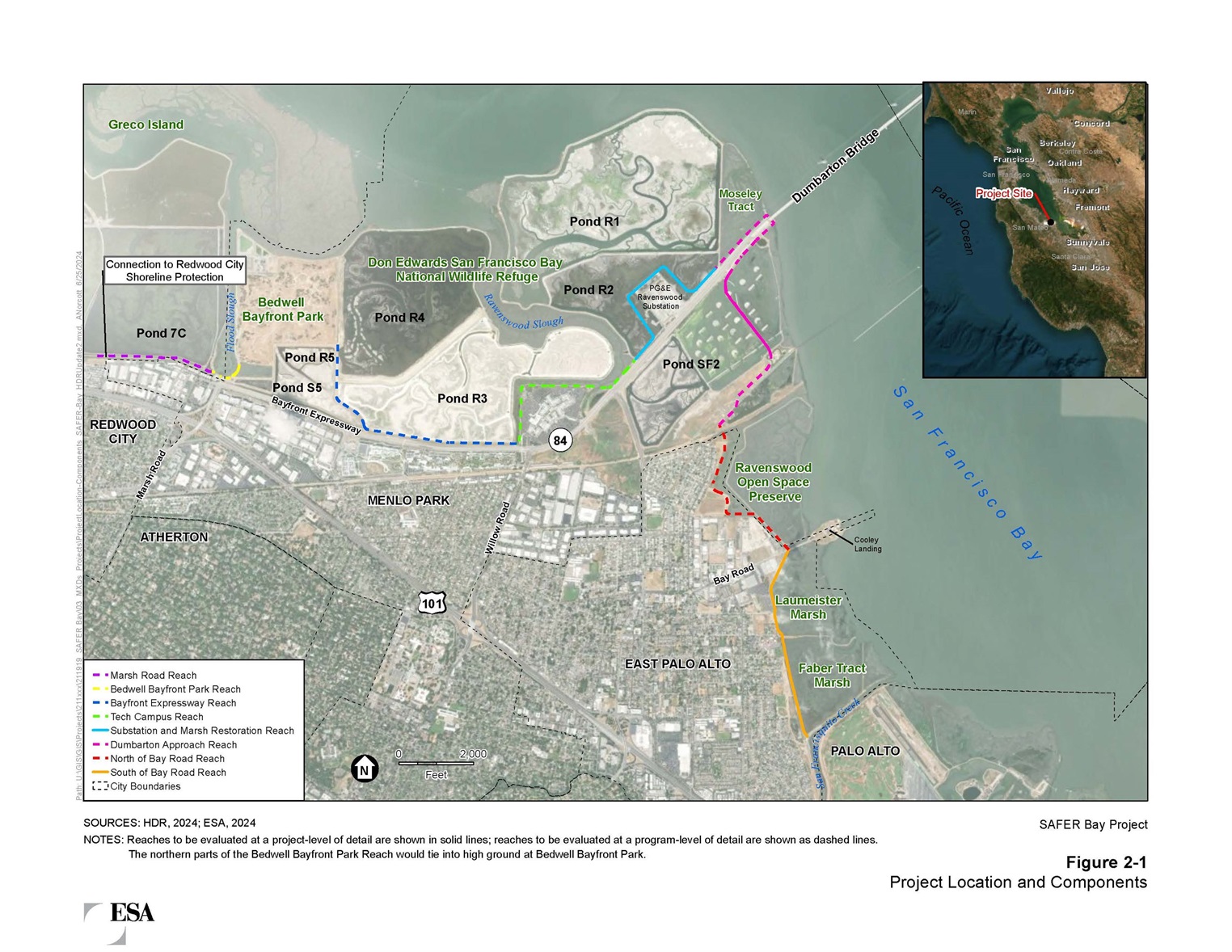
FIGURE - SAFER Bay project
Menlo Park SAFER Bay project
The Menlo Park SAFER Bay project includes a significant part of the overall SAFER Bay project. The reaches currently in design include:
- Bayfront Expressway Reach
- Tech Campus Reach
- Substation and Marsh Restoration Reach
Sea level rise improvements for the two other reaches will be part of a future design and construction project.
- Marsh Road Reach
- Bedwell Bayfront Park Reach
Project elements
The overall SAFER Bay project includes elements to protect the shoreline from coastal flooding and sea level rise, improve habitat and add recreation features. Typically flood protection elements like levees and flood walls alone would adversely affect tidal marsh habitats that are important for local wildlife, especially seabirds, threatened and endangered species. Habitat improvements are incorporated to offset these adverse effects, and are often referred to as “restoration” activities. Under the overall SAFER Bay project, approximately 1,000 acres of habitat improvements are proposed, which consist of tidal salt marsh restoration, enhancement of habitat for western snowy plover, creation of seabird islands in the Ravenswood Ponds, and restoration of salt marsh-upland transition habitat.
Funding
Funding is required for the design, environmental review, permitting and construction for each reach and the restoration activities. The SFCJPA and the cities of East Palo Alto and Menlo Park have each been awarded funds to advance the overall SAFER Bay project from a number of sources, including: FEMA’s Building Resilient Infrastructure and Communities (BRIC) and Hazard Mitigation Grant Program, the San Francisco Bay Restoration Authority Measure AA, and the California Department of Water Resources.
Menlo Park FEMA Grant
In December 2020, the City submitted a grant application to the California Office of Emergency Services (Cal OES) for the FEMA BRIC grant program along with partners SFCJPA, PG&E and Meta. The scope of work includes funding for engineering, design, environmental documentation, regulatory compliance, permitting, public outreach and construction of the project, from approximately the north side of the Dumbarton Bridge to the southeast side of Bedwell Bayfront Park. This area corresponds to three of the five reaches in Menlo Park and covers 3.7 miles of shoreline:
- Bayfront Expressway Reach
- Tech Campus Reach
- Substation and Marsh Restoration Reach
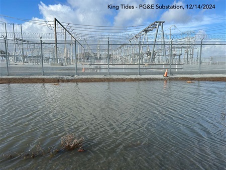
PG&E matching funds: PG&E’s Ravenswood Substation, a transmission-level electrical substation, is located within this portion of the City’s shoreline along the north side of Bayfront Expressway (State Route 84) near the western approach to the Dumbarton Bridge. The facility is part of critical power supply infrastructure providing electricity to portions of eight cities, including Menlo Park, serving approximately 300,000 residents. If flooded, the substation must be de-energized until floodwaters recede, and repair and maintenance activities must be completed before re-energizing, which could take several days in a major storm event. The geographic area served by the Ravenswood Substation generally extends from the City of San Mateo to the City of Palo Alto. As part of the FEMA BRIC grant, PG&E committed $10 million of local match funding the design and construction.
Meta matching funds: Meta’s Classic Campus, located at 1 Hacker Way, is also within this portion of the City’s shoreline on the bayside of Bayfront Expressway. Meta committed to provide up to $7.808 million in additional local match funding to help protect its property located on the bayside of Bayfront Expressway.
In total, the $17.808 million in committed local match funds from PG&E and Meta allowed the City to request the maximum $50 million in federal funds available from the FEMA BRIC program for the Project, which has substantial potential benefits to the City’s Bayfront and Belle Haven neighborhoods located on the hillside of Bayfront Expressway.
Current status
Menlo Park SAFER Bay project
Bayfront Expressway, Tech Campus Reaches, Substation and Marsh Restoration: With FEMA BRIC funding, the City is initiating the design for the three of the five reaches. The design and environmental documentation is estimated to take 22 months and is anticipated to be completed in spring 2027. Construction of the reaches would follow once full funding is secured.
Marsh Road, Bedwell Bayfront Park Reaches: This is a future phase that will require coordination with many stakeholders, including the City of Redwood City, and is dependent on identifying funding to perform the design and construction.
East Palo Alto SAFER Bay project
The East Palo Alto SAFER Bay project levee will run continuously in East Palo Alto from the O'Connor Street Storm Drain Pump Station to the city limits near University Avenue. The project is currently in the environmental and conceptual engineering stages.
Environmental Impact Report
The SFCJPA is developing the needed technical studies and preliminary engineering designs that will be incorporated into a draft Environmental Impact Report (EIR) for the overall SAFER Bay project. The draft EIR is planned for release in 2025.
As part of the final designs, the cities will supplement the EIR developed by the SFCJPA with additional studies.
Project history
-
February 2025 - Award professional services contract for the engineering, design, environmental documentation, regulatory compliance, permitting and public outreach.
-
Sept. 12, 2024 – Released Request for Proposals to perform engineering, design, environmental documentation, regulatory compliance, permitting, public outreach, and construction support for the project.
-
May 17, 2023 – Received notification that grant application had been approved and that $50 million had been set aside for the engineering, design, and construction of the Project. Funding allocated in amount of $3,759,474 for Phase 1, which covers the engineering, design, environmental documentation, regulatory compliance, permitting and public outreach for the project.
-
April 1, 2022 – Executed memorandum of understanding between City, SFCJPA, PG&E, and Meta
-
Dec. 3, 2020 – Submitted 2020 FEMA BRIC grant application